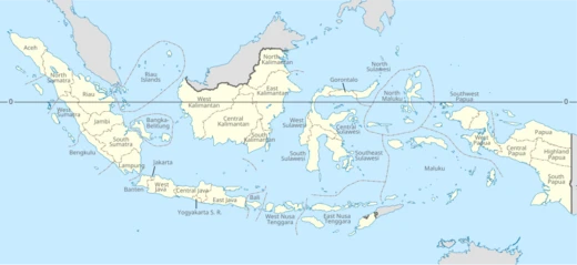
North Sulawesi
Province on Sulawesi's Minahasa Peninsula, capital Manado.

via Wikipedia: North Sulawesi · see source
North Sulawesi (Indonesian: Sulawesi Utara) is a province of Indonesia, mainly located on the Minahasa Peninsula of the island of Sulawesi, south of the Philippines and southeast of Sabah, Malaysia. It also includes various small archipelagoes between the Minahasa Peninsula and southern Philippines. The province's capital and largest city is Manado, which is also the main gateway and the economic center of the province. Other major towns include Tomohon and Bitung in the northern half, and Kotamobagu in the southern half. The province's area is 14,488.43 square kilometres (5,594.01 sq mi), and its population was 2,270,596 according to the 2010 census, rising to 2,621,923 at the 2020 Census, with an official estimate as at mid 2025 of 2,721,440.
- Area
- 14,488.43 square kilometres (5,594.01 sq mi)
- Population (2025 estimate)
- 2,721,440
- Capital
- Manado
- Largest city
- Manado
- Province created
- 14 August 1959
- Northernmost island
- Miangas
Verified Timeline
Lore & Background
The area around North Sulawesi used to be called Minahasa, a name etymologically derived from the words Mina-Esa (Minaesa) or Maesa which means 'being one' or 'uniting', reflecting a hope to unite various sub-ethnic groups including Tontemboan, Tombulu, Tonsea, Tolour (Tondano), Tonsawang, Ponosakan, Pasan and Bantik. The word 'Minahasa' was first used by J.D. Schierstein, the Dutch regent of Manado, in his report to the Governor of Maluku on 8 October 1789, where he defined it as Landraad or 'State Council'. Archaeological research has revealed signs of human life in North Sulawesi from 30,000 years ago, based on evidence in the cave Liang Sarru on the island of Salibabu. Other evidence shows life about 6,000 years ago on the Passo Hillside Site in Kakas District and 4,000 years ago to early AD at the Liang Tuo Mane'e cave in Arangkaa on Karakelong Island.
Reader's Guide
North Sulawesi in the past was an area of potential spices, rice and gold which became a battleground for the interests of economic hegemony between the Portuguese, Spanish, Dutch and the Kingdoms around this area. The Portuguese first landed on the area at the 16th century. Following decades of war, the area ultimately fell to the Dutch at the 17th century. The Dutch ruled for three centuries, before being ousted by the Japanese on the eve of World War II. After the Japanese surrender in 1945, the Dutch briefly regained possession, before finally leaving in 1949 following the Round Table Conference, in which the Dutch recognized the newly created United States of Indonesia (RIS). North Sulawesi was incorporated into the territory of the State of East Indonesia (NIT), which was later dissolved and merged into the RIS. On 17 August 1950, the RIS was officially disbanded and re-formed as the unitary state of the Republic of Indonesia. The island of Sulawesi was governed briefly as a single province, before being separated into several different provinces. The province of North Sulawesi was created on 14 August 1959. The western half of this area (comprising the Gorontalo Regency and the newly created Boalemo Regency) was separated from North Sulawesi on 5 December 2000 and established as the province of Gorontalo.
Did You Know?
- The province's furthest extent, the outlying and isolated island of Miangas to its north, is the northernmost island of Indonesia that has the country's sole and only border with the Philippines.
- There are 41 mountains in North Sulawesi with an altitude ranging from 1,112–1,995 metres (3,648–6,545 ft).
- The word 'Minahasa' was first used by J.D. Schierstein, the Dutch regent of Manado, in a report to the Governor of Maluku on 8 October 1789.
- Archaeological evidence in the cave Liang Sarru on the island of Salibabu shows signs of human life from 30,000 years ago.
- The western half of North Sulawesi (Gorontalo Regency and Boalemo Regency) was separated on 5 December 2000 to form the province of Gorontalo.
Frequently Asked Questions
What exactly is North Sulawesi?
It is a province of Indonesia situated primarily on the Minahasa Peninsula of Sulawesi island, with Manado serving as both its capital and largest city.
Where does North Sulawesi sit geographically?
The province is bordered by the Philippines to the north, the Maluku Sea to the east, Gorontalo to the west, and the Gulf of Tomini to the southwest.
When did North Sulawesi officially become its own province?
It was formally established as a province on 14 August 1959, following a long history as a contested territory between European colonial powers and local kingdoms.
How big is North Sulawesi and how many people live there?
The province covers roughly 14,488 square kilometres and is home to an estimated 2.72 million residents as of 2025.
What is the northernmost point in North Sulawesi?
The island of Miangas marks the province's farthest northern reach, sitting just south of the Philippine border.
More in Provinces Of Indonesia 1-24
Related in Provinces Of Indonesia
Links follow this subject's own source article.
Elsewhere in the Provinces Of Indonesia universe
Spotted an error? Know more?
This is a living reference — every entry is fact-audited, and reader corrections feed straight into our audit queue. Suggest an edit · See this site's audit record