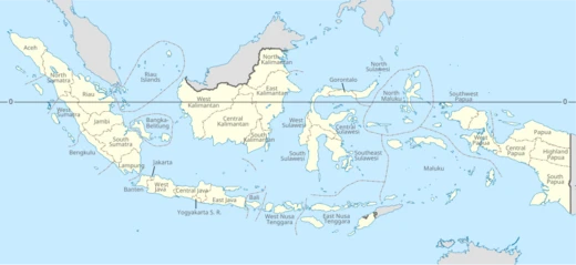
Central Sulawesi
Largest province on Sulawesi Island by area.

via Wikipedia: Central Sulawesi · see source
Central Sulawesi (Indonesian: Sulawesi Tengah) is a province of Indonesia located in the north-central part of the island of Sulawesi. The administrative capital and largest city is Palu. The province borders Gorontalo to the east, and Southeast Sulawesi, South Sulawesi, and West Sulawesi to the south, and shares maritime borders with East Kalimantan to the west, North Maluku to the east, and Malaysia and the Philippines to the north. According to BPS, Central Sulawesi has an area of 61,496.98 km² (23,744 sq mi), the largest area among all provinces on Sulawesi Island, and the second-largest population on Sulawesi after South Sulawesi. The 2020 Census recorded a population of 2,985,734, and the official estimate for mid-2025 was 3,156,100.
- Capital
- Palu
- Area
- 61,496.98 km² (23,744 sq mi)
- Population (2020 Census)
- 2,985,734
- Population (mid-2025 estimate)
- 3,156,100
- Established
- 13 April 1964
- Dominant Religion
- Islam
- Official Language
- Indonesian
Verified Timeline
Lore & Background
Central Sulawesi became a separate province on 13 April 1964, having previously been part of North Sulawesi. The province is inhabited by many ethnic groups, such as the Kaili and Tolitoli. The official language is Indonesian, used for official purposes and inter-ethnic communication, while several indigenous languages are spoken by Indigenous peoples. Islam is the dominant religion, followed by Christianity, which is mostly adhered to by people in the eastern part of the province. According to UNICEF, as many as 1 million people, or 35 percent of the total population, are children. More than three out of four children live in rural areas. More than 185,000 children (18.2 percent) lived below the provincial poverty line in 2015 (Rp. 11,127 per person per day). Three-quarters of children experience deprivation in two dimensions of non-income poverty or more, with inequality striking between urban and rural areas.
Reader's Guide
Central Sulawesi holds significant archaeological and historical importance. There are over 400 granite megaliths in the area of Lore Lindu National Park, around 30 representing human forms, varying in size from a few centimetres to approximately 4.5 metres. Their original purpose is unknown. Other megaliths include large stone pots (Kalamba) with stone lids (Tutu'na). Archaeological studies date the carvings from between 3000 BC to 1300 AD. The province has many caves, seven of which have ancient pictures; based on 2011 research by a joint Indonesian and Australian team, these pictures were drawn at least 40,000 years ago, about the same age as pictures found in the Caves of Monte Castillo, Spain. In the 13th century, several kingdoms were established, including the Kingdom of Banawa, Kingdom of Tawaeli, Kingdom of Sigi, Kingdom of Bangga, and Kingdom of Banggai. The influence of Islam began in the 16th century, a result of expansion by the Kingdom of Bone and the Kingdom of Wajo. Dutch traders arrived in the early 17th century, building fortifications in Parigi to combat piracy. The region was part of the Dutch East Indies for three centuries until Japanese occupation during World War II. After the Japanese surrendered, the area was incorporated into the Republic of Indonesia.
Did You Know?
- Central Sulawesi has over 400 granite megaliths in the Lore Lindu National Park, with around 30 representing human forms, dating from between 3000 BC to 1300 AD.
- Cave paintings in Central Sulawesi, researched in 2011 by a joint Indonesian and Australian team, were drawn at least 40,000 years ago, about the same age as the oldest known ancient pictures in Europe found in Spain's Caves of Monte Castillo.
- The province has the largest area among all provinces on Sulawesi Island, at 61,496.98 km².
- According to UNICEF, 35 percent of Central Sulawesi's total population are children, and more than three out of four children live in rural areas.
- The first organization to establish a branch in Central Sulawesi was Sarekat Islam (SI), set up in Buol Toli-Toli in 1916.
Administrative Identity & Regional Placement
Central Sulawesi occupies a position within one of Indonesia's two principal geographical divisions. As one of seventeen provinces that make up Eastern Indonesia, it belongs to the broader Sulawesi geographical unit, which sits alongside the Lesser Sunda Islands, the Maluku Islands, and Papua as the four foundational territorial blocks of the region. The wider Eastern Indonesian territory stretches from the Southern Philippines and Palau to the north, borders Papua New Guinea on its eastern edge, and faces Northern Australia to the south. Time-wise, the region operates under two national standards: Central Indonesian Time at UTC+8 and Eastern Indonesia Time at UTC+9, reflecting the vast longitudinal span of the archipelago. This administrative framework places Central Sulawesi within a complex web of provincial and regional governance that has shaped its political identity since the mid-twentieth century.
Colonial Inheritance & the Birth of a State
The territorial concept that now encompasses Central Sulawesi traces its roots to the final chapters of Dutch colonial rule, when the lands east of Java and Kalimantan were collectively labeled the Great East. Following the Denpasar Conference held on 24 December 1946, the State of East Indonesia was formally established, encompassing the same broad area though excluding Western New Guinea, which had been part of the earlier Malino Conference arrangement. This new state functioned as a constituent unit within the United States of Indonesia, a brief federal experiment. On 17 August 1950, the federal structure was dissolved, and the territory was absorbed into the unitary Republic of Indonesia. Central Sulawesi, as one of the seventeen provinces that emerged from this consolidation, inherited a political identity forged in the transition from colonial administration to independent nationhood.
Tropical Climate & Seasonal Rhythms
The climate across Eastern Indonesia, where Central Sulawesi is situated, follows a broadly consistent tropical rhythm. From October through March, days tend to be dry and bathed in sunshine, offering a prolonged stretch of clear weather. The warm tropical rain season then arrives between May and August, bringing the region's principal wet period. Throughout the entire year, temperatures remain remarkably stable, typically hovering between 27 degrees Celsius (81 degrees Fahrenheit) and 30 degrees Celsius (86 degrees Fahrenheit). This narrow thermal band means that seasonal variation is expressed more through shifts in precipitation and humidity than through dramatic changes in warmth. For a province like Central Sulawesi, embedded within this climatic envelope, the predictable alternation between dry and wet months has historically shaped agricultural cycles, coastal livelihoods, and the daily rhythms of communities spread across the region's islands and peninsulas.
Coastal Livelihoods & the Digital Economy
For generations, seaweed farming has served as a cornerstone of coastal commerce throughout Eastern Indonesia, with communities along the shores cultivating this marine crop as a reliable source of income. However, the 2020s have brought mounting challenges as climate change in Indonesia has begun to erode both the revenue and harvest volumes that seaweed farmers depend upon, threatening a traditional livelihood that has sustained coastal populations for decades. In stark contrast to this agrarian struggle, the region's consumer economy has undergone a rapid digital transformation. Online shopping transactions in Eastern Indonesia doubled between 2020 and 2021, a surge driven largely by the Indonesian e-commerce platform Tokopedia. The most popular product categories in the region include health and beauty goods, fashion, food and beverage items, and electronics, signaling a consumer base increasingly connected to national and global markets through digital channels.
Gallery

Frequently Asked Questions
Who is Central Sulawesi?
Central Sulawesi is a province situated in the north-central region of Sulawesi Island, Indonesia, with Palu serving as both its administrative capital and largest city. It was formally established on 13 April 1964.
What are Central Sulawesi's powers/role?
It holds the distinction of being the largest province on Sulawesi by area, spanning roughly 61,500 square kilometers. It also ranks as the island's second-most populous province behind South Sulawesi, with a mid-2025 population estimate of about 3.16 million.
How does Central Sulawesi's story end?
Central Sulawesi's story has no ending—it remains an active, functioning province within Indonesia today. Its historical arc spans pre-colonial kingdoms, Dutch colonial rule, Japanese occupation during World War II, and its 1964 establishment as a formal province.
Why is Central Sulawesi important?
The province is home to ancient megalithic structures and cave paintings dating back at least 40,000 years, making it a critical site for studying early human presence in the region. Islam is the dominant faith, and its sheer size and population give it a major role in Sulawesi's overall identity.
Where does Central Sulawesi live?
Central Sulawesi occupies the north-central stretch of Sulawesi Island in Indonesia. Its capital city, Palu, sits along the island's central bay area.
More in Provinces Of Indonesia 1-24
Related in Provinces Of Indonesia
Links follow this subject's own source article.
Elsewhere in the Provinces Of Indonesia universe
Spotted an error? Know more?
This is a living reference — every entry is fact-audited, and reader corrections feed straight into our audit queue. Suggest an edit · See this site's audit record