Central Papua
Indonesian province in central Western New Guinea, established in 2022.

via Wikipedia: Central Papua · see source
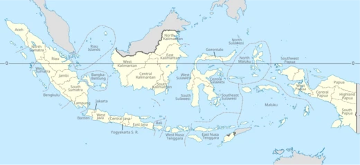
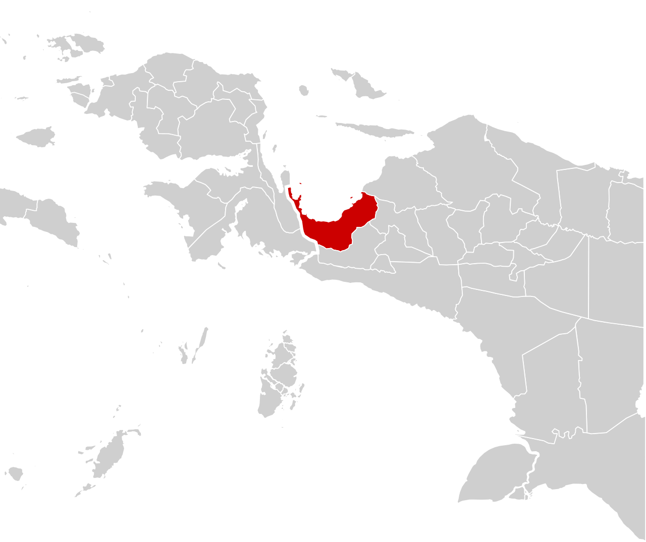
Central Papua, officially the Central Papua Province (Indonesian: Provinsi Papua Tengah), is an Indonesian province located in the central region of Western New Guinea. It was formally established on 25 July 2022 from the former eight western regencies of the province of Papua. It covers an area of 61,079.59 km2 and had an officially estimated population of 1,492,290 in mid 2025 (comprising 793,480 males and 698,810 females), increasing by about 18,500 people per year. It is bordered by the Indonesian provinces of West Papua to the west, the province of Papua to the north and northeast, by Highland Papua to the east, and by South Papua to the southeast. The administrative capital is located in Wanggar District in Nabire Regency, although Timika (in Mimika Regency) is a larger town. Its traditional name is Mee Pago – Saireri.
- Established
- 25 July 2022
- Area
- 61,079.59 km²
- Population (mid 2025)
- 1,492,290
- Capital
- Wanggar District, Nabire Regency
- Largest town
- Timika
- Traditional name
- Mee Pago – Saireri
Verified Timeline
Lore & Background
Central Papua's provincial border roughly follows the cultural region of Mee Pago and parts of Saireri. Since the 18th century, the western region of Mimika was the furthest reach of the Tidore Sultanate's "Uli Siwa" influence on the south-west coast of Papua Island. Trade relations for slaves, ironwares, clothes, and body ornaments were established, and local populations adopted titles of Moluccan origin (raja, mayor, kapitan, and orang tua) as well as Islamic culture, such as the use of turbaned hats and the custom of not eating pork until the 1950s. The trading centre was Kipia, led by a leader named Naowa, who received the title of king from Lamora, Namatota (Koiwai) King. Kipia led a confederation of Kamoro villages called Tarya We, along with Poraoka, Maparpe, Wumuka, Umar, and Aindua. This influence gradually disappeared with the strengthening of Dutch colonialism and the influx of Catholic missionaries and Chinese traders. During the Dutch East Indies era, the interior was inhabited by ethnic groups such as the Mee (Ekari) and Moni. These communities were first discovered by Western explorers during the British Ornithologists' Union 1909–1911 expedition to Western New Guinea; they were called Tapiro pygmies on account of their shorter height compared to the Kamoro. In the 1930s, Dutch pilot Frits Wissel flew over the highland area and came across three large lakes where the Mee people resided—Paniai, Tigi, and Tage—which the Dutch called Wisselmeeren. The region was later designated as the Central New Guinea afdeling on 10 May 1952, though it did not have a capital city. In 1936, the Carstensz expedition, led by Anton Colijn, conquered Puncak Jaya; geologist Jean Jacques Dozy discovered large copper deposits at a location later named Ertsberg. This report was rediscovered by the Freeport Sulfur Company in 1963, leading to an expedition by Forbes Wilson and geologist Delos Flint. They signed the first contract with the Government of Indonesia under President Suharto, who had just passed Law No. 1 of 1967 concerning Foreign Investment. The mine opened in 1970, and the Amungme people were relocated. Freeport also built Amamapare Port in the Kamoro Tribe area and a settlement called Kuala Kencana in 1995, then opened the Grasberg mine in Tembagapura in 1991. Efforts to split Papua Province (formerly Irian Jaya) began under Governor Busiri Suryowinoto, who proposed dividing Irian Jaya into three provinces—East, Central, and West Irian Jaya—in a concept that Kompas journalist Korano Nicolash LMS called the first that "contained a comprehensive and detailed division of Irian Jaya into three provinces." Central Irian Jaya was to consist of Mapurajaya, Nabire, Enarotali (Paniai), Mulia, Yapen-Waropen (Serui), and Teluk Cenderawasih (Biak). President Suharto approved the division into three assistant governorates in 1984. President B.J. Habibie approved the division through Law Number 45 of 1999, enacted on 4 October 1999; former Assistant Governor of Region II Herman Monim was inaugurated as the first Governor of Central Irian Jaya on 12 October 1999. However, the Irian Jaya DPRD opposed and unilaterally cancelled the division four days later, and the central government withdrew the law. After Irian Jaya was renamed Papua in 2000, demands resurfaced. On 23 August 2003, Andreas Anggaibak (Chairman of the Mimika DPRD), Jacobus Muyapa (Chairman of the Paniai DPRD), and Philip Wona (Regent of Yapen Waropen) declared the formation of Central Papua province. This polarized the community into supporting and rejecting groups, who fought and held each other hostage for about a week until the central government postponed the division on 28 August; the two parties reconciled the next day, but the fighting left five people dead and dozens injured. The province was finally established on 25 July 2022.
Reader's Guide
Central Papua was formally established on 25 July 2022 from the former eight western regencies of the province of Papua. Its provincial border roughly follows the cultural region of Mee Pago and parts of Saireri. The province covers an area of 61,079.59 km2 and had an officially estimated population of 1,492,290 in mid 2025, increasing by about 18,500 people per year. The administrative capital is located in Wanggar District in Nabire Regency, although Timika (in Mimika Regency) is a larger town. Central Papua is bordered by seas to the north and south. Nabire is situated in the northern part, a lowland area directly adjacent to the Teluk Cenderawasih National Park, with potential for marine tourism including coral reefs, white sandy islands, and whale sharks. The southern part is mostly swampy terrain and the location of the port of Amamapare and Timika. The central region is dominated by the Jayawijaya Mountains, which encompass the snow-capped Puncak Jaya, the highest peak in Indonesia. This mountain range is also home to the Grasberg gold mine, operated by Freeport Indonesia. Historically, the region was influenced by the Sultanate of Tidore from the 18th century, with trade relations for slaves, ironwares, clothes, and body ornaments. The trading centre was Kipia, led by Naowa, who received the title of king from Lamora, Namatota (Koiwai) King. During the Dutch East Indies era, the interior was inhabited by the Mee (Ekari) and Moni, who lived by clearing fields, cultivating tubers, raising pigs, fishing, and feasting, using mege currency made from shells. They were first discovered by Western explorers during the British Ornithologists' Union 1909–1911 expedition. In the 1930s, Dutch pilot Frits Wissel discovered three large lakes—Paniai, Tigi, and Tage—which the Dutch called Wisselmeeren. In 1936, the Carstensz expedition discovered copper deposits at Ertsberg, leading to Freeport Indonesia's entry. The first contract was signed in 1967 under President Suharto, the mine opened in 1970, and the Grasberg mine opened in 1991. Efforts to split the province date back to the New Order under Governor Busiri Suryowinoto, who proposed dividing Irian Jaya into three provinces. President B.J. Habibie approved the division in 1999, but it was cancelled after opposition from the Irian Jaya DPRD. A declaration of Central Papua province on 23 August 2003 led to conflict, with five deaths and dozens injured, until the central government postponed the division on 28 August. The province was finally established on 25 July 2022.
Did You Know?
- Central Papua's population in mid 2025 was estimated at 1,492,290, comprising 793,480 males and 698,810 females, increasing by about 18,500 people per year.
- The trading centre of Kipia was led by a leader named Naowa, who received the title of king from Lamora, Namatota (Koiwai) King.
- Dutch pilot Frits Wissel discovered three large lakes—Paniai, Tigi, and Tage—in the 1930s, which the Dutch called Wisselmeeren.
- The Carstensz expedition in 1936 conquered Puncak Jaya and discovered large copper deposits at a location later named Ertsberg.
- The declaration of Central Papua province on 23 August 2003 led to fighting that left five people dead and dozens injured.
Birth of a New Province
In 2022, the Indonesian government finally broke a nine-year freeze on provincial creation that had been in place since 2013. That year, four new provinces were carved out of the existing province of Papua: Central Papua, Highland Papua, South Papua, and Southwest Papua. These four entities immediately became the youngest administrative divisions in the nation, joining a total count of 38 provinces spread across the archipelago. The decision to split the former single Papua province into smaller units marked a significant shift in Indonesia's territorial governance, as the moratorium had previously halted all proposals for additional provinces. Central Papua thus entered the national map not as a long-standing region with deep administrative roots, but as a freshly constituted entity whose boundaries, institutions, and local identity were still in their earliest stages of development. Its creation reflected a broader governmental willingness to respond to calls for more localized administration in geographically vast and culturally distinct areas of the country.
Governance Structure & Electoral Framework
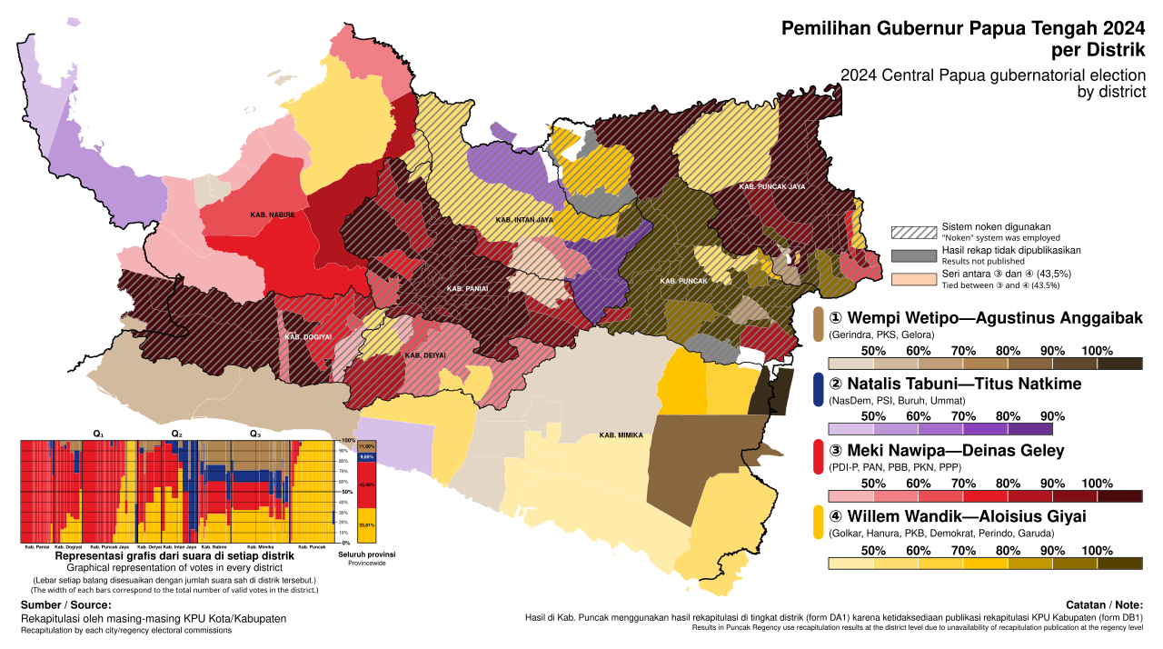
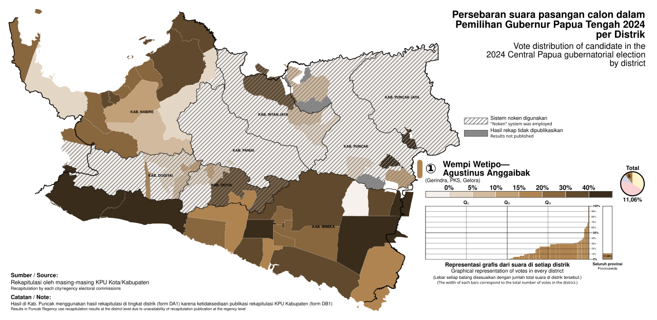
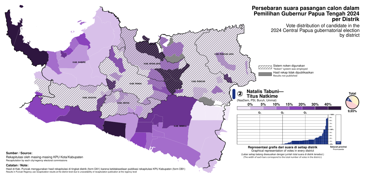
Like every province in Indonesia, Central Papua operates under a local government headed by a governor and a vice-governor, supported by a regional legislative assembly known as the DPRD Provinsi. Both the executive leaders and the members of this representative body are chosen through popular vote for five-year terms, with an additional constraint that a governor may serve no more than two consecutive terms. The elections for DPRD members are conducted simultaneously with the national general election, while gubernatorial races have been synchronized with other regional head elections since 2015. This coordination was part of a broader reform that culminated in simultaneous elections for all local executive posts in November 2024, with the next cycle set to occur every five years thereafter. Beneath the provincial level, Central Papua is subdivided into regencies and cities, which are further broken down into districts called kecamatan. The provincial government retains the authority to regulate and manage its own affairs, though this power remains subject to the overarching limits set by the central government in Jakarta.
Constitutional Mandate & Provincial Powers
The legal foundation for Central Papua's existence and authority traces back to Article 18, paragraph 1, of Indonesia's 1945 Constitution, which mandates that the unitary state be divided into provincial regions, each with its own regional government regulated by law. This constitutional provision is applied across the entire archipelago, reinforcing administrative cohesion over both land and maritime territories. More specifically, the Law on Regional Government (UU 23/2014) enumerates the concrete powers of a provincial government, including development planning, public order, provision of infrastructure, health services, education, environmental control, defense coordination, population registration, and investment administration. Crucially, these authorities apply to matters that span multiple regencies or cities, or whose benefits and impacts cross municipal boundaries, or that are more resource-efficient when managed at the provincial tier. For a newly created province like Central Papua, this framework defines the scope of what its government can independently regulate, while ensuring that responsibilities too small or too localized remain with the regency and city level.
Special Autonomy & the Papua Question
Indonesia's Constitution, particularly Article 18 as amended in October 1999 following the fall of Suharto, calls for the decentralization of power and autonomy to provinces. While the country is not a federated state, nine provinces have been granted special autonomous status under the designations Istimewa or Khusus. The province of Papua was among those granted special autonomy, a recognition rooted in the region's distinct cultural and political circumstances. The specific form this autonomy takes is not standardized across provinces; rather, each receives a tailored formulation shaped by particular political imperatives. Central Papua, as one of the four new provinces carved from the former Papua in 2022, inherits its place within this broader autonomy framework. The special status of the wider Papua region sets a distinctive backdrop against which the new province's own governance evolves, even as the precise boundaries of its autonomous powers continue to be defined through subsequent legislation and political negotiation.
Gallery
Frequently Asked Questions
What is Central Papua?
Central Papua (Papua Tengah) is a province in the central part of Western New Guinea that became part of Indonesia's administrative map in 2022. It encompasses the former western regencies of the old Papua province.
When was Central Papua created and how?
The province was officially established on 25 July 2022 by carving out the eight western regencies from the existing Papua province. This split was part of Indonesia's broader effort to subdivide its large eastern provinces for better local governance.
What is the capital of Central Papua?
The administrative capital sits in Wanggar District within Nabire Regency, though the larger and more well-known town in the province is Timika in Mimika Regency.
How large is Central Papua in terms of area and population?
The province spans roughly 61,080 square kilometres and had an estimated population of about 1.49 million people as of mid-2025.
What is the traditional name of Central Papua?
Locally, the region is known as Mee Pago – Saireri, a name rooted in the indigenous cultural identity of the peoples who have lived in the central highlands of Western New Guinea for generations.
More in Provinces Of Indonesia 1-24
Elsewhere in the Provinces Of Indonesia universe
Spotted an error? Know more?
This is a living reference — every entry is fact-audited, and reader corrections feed straight into our audit queue. Suggest an edit · See this site's audit record